| Previous Date | Day By Day Index | 16th OVI Home Page | Next Date |
Where was the regiment on
Thursday, May 19, 1864
On this day, the 16th Ohio moved from yesterday's battle line and marched back across Yellow Bayou, Louisiana. The regiment marched six miles south along the east bank of the bayou, looking for any signs the Rebels were planning a flanking movement. The regiment returned to spend the night near the crossing of Yellow Bayou. Cpl. Theodore Wolbach, Company E, gives us the details:
On the 19th, in the morning, we marched back across the Yellow bayou. After a short rest we took a long tramp down the east bank of that stream in search of any of the enemy that might be in that direction. Our advance encountered a small force that fired and fled. Later in the day three men were captured while trying to cross a bayou in a skiff. One of them proved to be Gen. Dick Taylor's A.A. Adj. Gen. There was some significance in their presence here. Probably a flank movement was intended. Whatever the enemy's plan might have been our sudden appearance checkmated them. While we were down here looking after things, a mammoth bridge of steamboats was formed across the river up at the crossing. Over this the army and its trains and material passed.
Wolbach's reference to the mammoth bridge
refers to more work by engineer Lt. Col. Joseph Bailey, the engineer who, just a few weeks earlier, had successfully dammed the Red River at Alexandria, Louisiana, and saved the Federal gunboat fleet, and who now directed the creation of a bridge over the Atchafalaya River consisting of the lashing together of steamboats, all crossing the river, and adding a bridge of wooden planks across the bows of the ships, allowing Gen. Banks' entire army to cross with relative ease.
Of today's activities Pvt. Robert Newt Gorsuch, Company B, adds:
Move back across bayou and go four miles below and form lines and remain there till evening when we return to the ferry and encamp. Wagons crossing all night.
From three different references to the distance the regiment marched this day, we are told two miles (Perrine), four miles (Gorsuch) and six miles (Reid). Given the length of the bayou and other factors, we are assuming the more accurate distance is six miles.
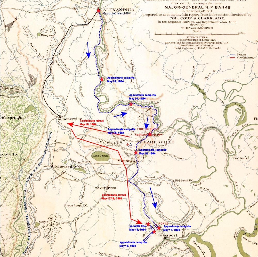
This period military map shows the approximate route taken by the 16th Ohio and other troops under Gen. Nathaniel Banks as they evacuated Alexandria, Louisiana, heading south and east along the Red River. On May 19, 1864, the 16th Ohio moved to a position south, several miles, along the east bank of Yellow Bayou and formed a defensive line in case the Confederates tried to flank the Union forces moving along the road from Yellow Bayou to the Atchafalaya River, farther south. In the evening, the regiment moved back to near the crossing of the bayou and camped for the night.
Note that original military attributions on the map reflect the earlier routes of Gen. Banks when he first marched up the Red River in an attempt to capture Shreveport, Louisiana.
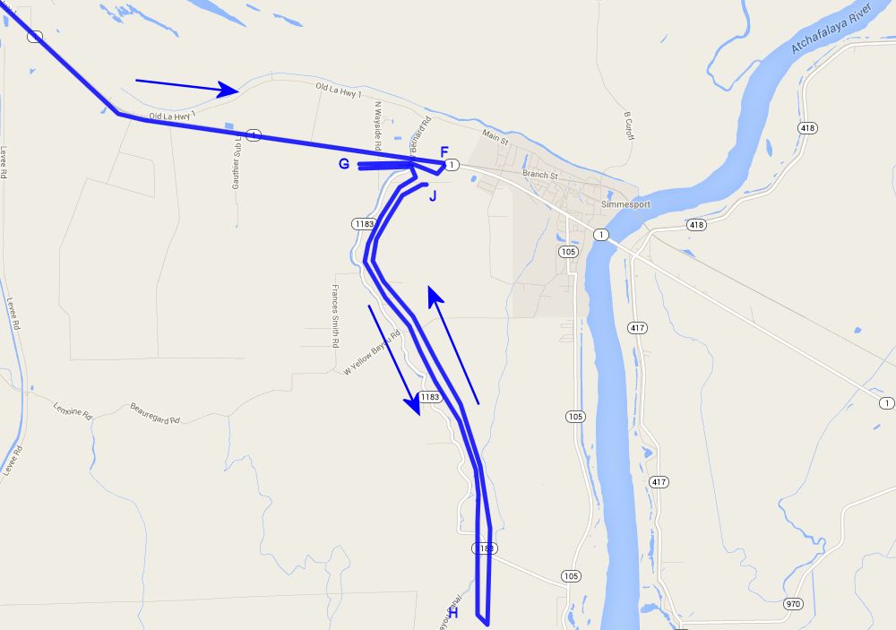
Modern day close view map showing the estimated route and location of the 16th Ohio on its march from Alexandria, Louisiana, southeast along the Red River toward the Mississippi River, retreating from the attacks of Confederate General Richard Taylor.
F - Approximate location of the 16th Ohio when it camped for the night of May 17, 1864, just east of Yellow Bayou, Louisiana.
G - Approximate location of the 16th Ohio when it camped on the battle line of the Battle of Yellow Bayou, on the night of May 18, 1864.
H - Approximate location of the 16th Ohio where it spend part of the day in battle line guarding against any flanking movement by Gen. Richard Taylor's Rebels on May 19, 1864.
J - Approximate location of the 16th Ohio where it camped for the night of May 19, 1864, near the crossing of Yellow Bayou, Louisiana.
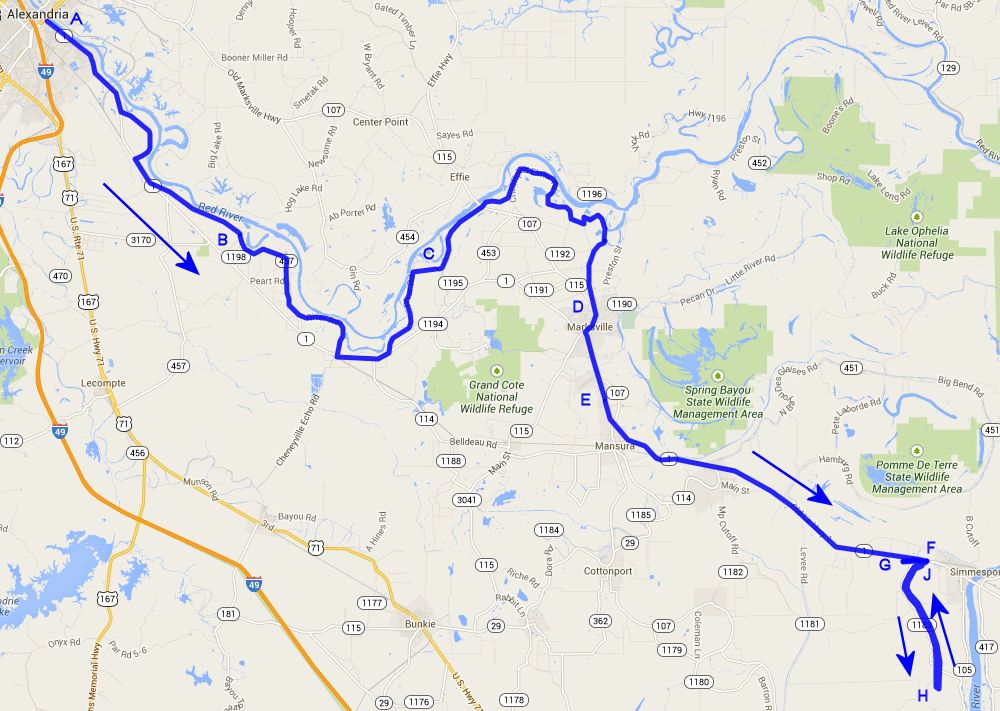
Modern day overall view map showing the estimated route and location of the 16th Ohio on its march from Alexandria, Louisiana, southeast along the Red River toward the Mississippi River, retreating from the attacks of Confederate General Richard Taylor.
A - Alexandria, Louisiana, where the 16th Ohio fought and labored since April 26, 1864, leaving about 2:00pm on May 13, 1864.
B - Estimated location of the 16th Ohio when it camped for the night of May 13, 1864.
C - Highly estimated location of the 16th Ohio when it camped for the night of May 14, 1864.
D - Approximate location of the 16th Ohio when it camped for the night of May 15, 1864, near Ft. DeRussy, Louisiana.
E - Approximate location of the 16th Ohio when it camped for the night of May 16, 1864, below Marksville, Louisiana, and near where an unnamed bayou crosses the road.
F - Approximate location of the 16th Ohio when it camped for the night of May 17, 1864, just east of Yellow Bayou, Louisiana.
G - Approximate location of the 16th Ohio when it camped on the battle line of the Battle of Yellow Bayou, on the night of May 18, 1864.
H - Approximate location of the 16th Ohio where it spend part of the day in battle line guarding against any flanking movement by Gen. Richard Taylor's Rebels on May 19, 1864.
J - Approximate location of the 16th Ohio where it camped for the night of May 19, 1864, near the crossing of Yellow Bayou, Louisiana.
| Previous Date | Day By Day Index | 16th OVI Home Page | Next Date |