| Previous Thompson's Hill Battle Map | Thompson's Hill Index Page | 16th OVI Home Page |
Map #2 of Battle of Thompson's Hill (Port Gibson)
May 1, 1863
From History of the 42nd Ohio
May 1, 1863
From History of the 42nd Ohio
Web Author's Notes:
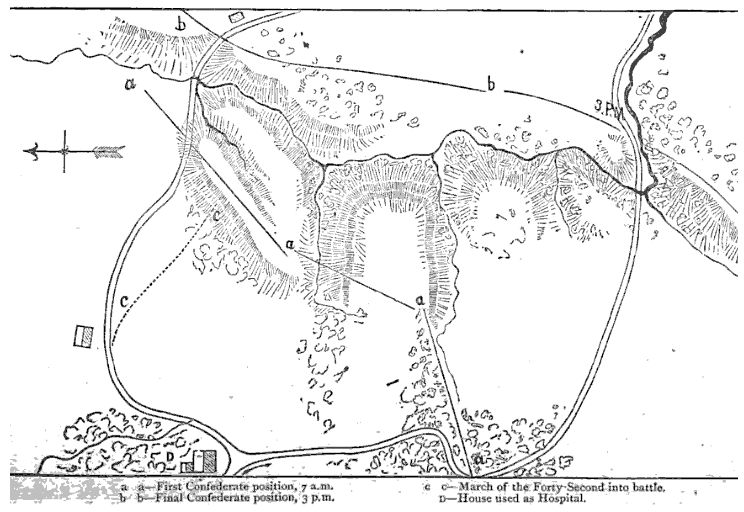
This military battle map was found in the book The Forty-Second Ohio Infantry - A History of the Organization and Services of That Regiment in the War of the Rebellion, 1876 - F. H. Mason, late Private of Company A - Cobb, Andrews & Co., Publishers. This map is from the perspective of the 42nd Ohio which was brigaded with the 16th Ohio under Gen. Peter Osterhaus. Item "D" is the Shaifer House, used as General McClernand's headquarters and a Union hospital and, it is believed, near where the first encounter with the Rebels occurred just after midnight on May 1, 1863. Note that Generals Carr and Hovey first pursued the Rebels using the southern or right road. The Rebels retreated across the hills and ravines to the left road where Osterhaus and the 16th Ohio engaged them. Both roads lead to the village of Port Gibson which is off the map to the upper right.
This military battle map was found in the book The Forty-Second Ohio Infantry - A History of the Organization and Services of That Regiment in the War of the Rebellion, 1876 - F. H. Mason, late Private of Company A - Cobb, Andrews & Co., Publishers. This map is from the perspective of the 42nd Ohio which was brigaded with the 16th Ohio under Gen. Peter Osterhaus. Item "D" is the Shaifer House, used as General McClernand's headquarters and a Union hospital and, it is believed, near where the first encounter with the Rebels occurred just after midnight on May 1, 1863. Note that Generals Carr and Hovey first pursued the Rebels using the southern or right road. The Rebels retreated across the hills and ravines to the left road where Osterhaus and the 16th Ohio engaged them. Both roads lead to the village of Port Gibson which is off the map to the upper right.
| Previous Thompson's Hill Battle Map | Thompson's Hill Index Page | 16th OVI Home Page |